jueves, 7 de agosto de 2014

CENTRAL PACIFIC

CENTRAL PACIFIC * Full update/Warnings*
NASA Sees Heavy Rainfall in Iselle as the Hurricane Nears Hawaii
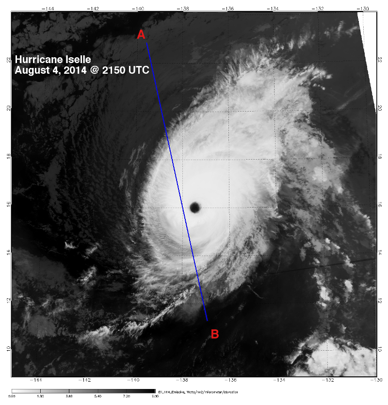
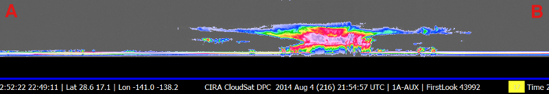
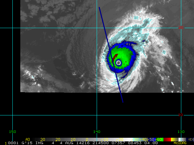
A NASA satellite has observed heavy rainfall in Hurricane Iselle on its approach to Hawaii. (In this image, Iselle is to the left, and Julio is to the right)
STORY/IMAGES: http://www.nasa.gov/content/goddard/iselle-eastern-pacific-ocean


 CENTRAL PACIFIC * full de actualización / Advertencias *
NASA ve fuertes lluvias en Iselle como el huracán se acerca a Hawaii
Un satélite de la NASA ha observado fuertes lluvias en el huracán Iselle en su enfoque a Hawai. (En la foto, Iselle está a la izquierda, y Julio está a la derecha)
HISTORIA / IMAGES: http://www.nasa.gov/content/goddard/iselle-oriental y el Pacífico-
océano


Video especial: Película de satélite

Special VIdeo: Satellite Movie Shows Hurricane Iselle and Julio Moving Toward Hawaii
This animation of NOAA's GOES-East satellite imagery from August 2 through 7 shows the movement of Hurricanes Iselle (left) and Julio (right) toward the Hawaiian Islands. Credit: NASA/NOAA GOES Project https://www.youtube.com/watch?v=3cEVueQ45-U


Video especial: Película de satélite muestra el huracán Iselle y Julio Ir hacia Hawaii
Esta animación de NOAA GOES-Este las imágenes de satélite a partir del 2 de agosto al 7 muestra el movimiento de los huracanes Iselle (izquierda) y Julio (derecha) hacia las islas de Hawai. Crédito: NASA / NOAA VA Proyecto https://www.youtube.com/watch?v=3cEVueQ45-U

Hurricane ...Emit a Gamma-Ray Flash

NW PACIFIC *Full Update* NASA Sees Hurricane Julio Organize and Emit a Gamma-Ray Flash
NASA's Fermi and Aqua satellites captured two different views of bursts of strength show by Hurricane Julio as it intensified. NASA's Fermi satellite saw a gamma-ray flash from Julio, while NASA's Aqua satellite saw Julio become more structurally organized as a hurricane. STORY/IMAGES:
http://www.nasa.gov/content/goddard/julio/
 
 
  NW PACÍFICO * actualización completa * NASA ve el huracán Julio Organizar y Emitir una flash Gamma-Ray
Satélites Fermi y Aqua de la NASA capturó a dos puntos de vista diferentes de ráfagas de fuerza mostrado por el huracán Julio, ya que se intensificó. Satélite Fermi de la NASA vio un destello de rayos gamma de Julio, mientras que el satélite Aqua de la NASA vio Julio organizarse más estructuralmente como un huracán. HISTORIA / FOTO:
http://www.nasa.gov/content/goddard/julio/

NW PACIFIC Super-typhoon

NW PACIFIC *Here's the full update on Super-typhoon Genevieve as promised: NASA Sees Genevieve Cross International Date Line as a Super-Typhoon
Tropical Storm Genevieve had ups and downs in the Eastern Pacific and Central Pacific over the last week but once the storm crossed the International Dateline in the Pacific, it rapidly intensified into a Super Typhoon.
http://www.nasa.gov/content/goddard/genevieve-eastern-pacific-ocean/
 
 
 NW PACÍFICO * Aquí está la actualización completa sobre el Super-tifón Genevieve según lo prometido: NASA ve Date Line Genevieve Cross International como un Super-Typhoon
La tormenta tropical Genevieve tuvo altibajos en el Pacífico Oriental y el Pacífico central durante la última semana, pero una vez que la tormenta cruzó la línea de fecha internacional en el Pacífico, se intensificó rápidamente en un súper tifón.
http://www.nasa.gov/content/goddard/genevieve-oriental y el Pacífico-ocean/

Hurricane Iselle

Hurricane Iselle

CloudSat overpassed Hurricane Iselle in the Pacific Ocean on August 4, 2014 at 2150 UTC. Iselle contained maximum sustained winds of 132 mph (115 knots) with a minimum central pressure of 951 mb. CloudSat overpassed just to the west of the center of compact storm intersecting the eyewall.
The Moderate Resolution Imaging Spectroradiometer (MODIS) on NASA's Aqua satellite captured the infrared (IR) (Figure 1) image taken a few minutes before the CloudSat overpass (Figure 2) denoted by the blue line A->B). The 1km Enhanced Infrared (IR) Imagery, Figure 3, also shows the CloudSat track during the same time period. This imagery distinguishes between cold and warm cloud top temperatures using IR imagery (higher cloud tops -> colder temperatures).
Hurricane Iselle was moving slowly westward towards Hawaii during the time of this overpass. The structure of Iselle is the classic annular structure with a well defined eye surrounded by a ring of deep convection. The CloudSat overpass (Figure 2) intersects this section of dense, convective cloud tops with cloud top heights around 15-16 km. The CloudSat cloud profiling signal attenuates in areas of moderate to heavy precipitation, quite evident from the convective cores in the CloudSat overpass. Cirrus cloud tops extend outwards from the storm to the northwest and southeast along the track of the descending CloudSat overpass.
An animation containing GOES satellite imagery with CloudSat imagery overlaid is shown in Figure 4 (courtesy Shigeru Suzuki of JPL).
Figure 1. MODIS IR imagery (courtesy NOAA LAADS Web).
Figure 2. CloudSat overpass track (courtesy CloudSat Data Processing Center).
Figure 3. 1km Remapped Color Enhanced Infrared Imagery (courtesy RAMMB).

Figure 4. Hurricane Iselle Animation - Pacific Ocean, August 4, 2014.

References:
NHC, Hurricane Iselle Advisory Archive, Retrieved August 6, 2014.
MODIS imagery, LAADS Web, Retrieved August 6, 2014.
1km Remapped Color Enhanced Infrared Imagery, Hurricane Iselle, Retrieved August 6, 2014. 


 huracán Iselle

CloudSat sobrepasado huracán Iselle en el Océano Pacífico el 4 de agosto de 2014 a 2150 UTC. Iselle contenía vientos máximos sostenidos de 132 mph (115 nudos) con una presión mínima central de 951 mb. CloudSat sobrepasado justo al oeste del centro de la tormenta compacto que corta la pared del ojo.

La resolución moderada (MODIS) en el satélite Aqua de la NASA capturó los rayos infrarrojos (IR) imagen tomada pocos minutos antes de que el paso elevado CloudSat (Figura 1) (Figura 2) indicada por la línea azul A-> B). El Enhanced Infrared (IR) Imágenes de 1km, Figura 3, muestra también la pista CloudSat durante el mismo período de tiempo. Esta imaginería distingue entre temperaturas superiores nube fría y caliente, utilizando imágenes de IR (mayores cimas de las nubes -> temperaturas más frías).

Huracán Iselle se movía lentamente hacia el oeste hacia Hawai durante el tiempo de este paso elevado. La estructura de Iselle es la estructura anular clásico con un ojo bien definido rodeado por un anillo de convección profunda. El paso elevado CloudSat (Figura 2) se cruza esta sección de, densas nubes convectivas con altos nube alturas alrededor de 15-16 km. La señal de perfiles de nubes CloudSat atenúa en las zonas de moderada a fuertes precipitaciones, bastante evidente a partir de los núcleos convectivos en el paso elevado CloudSat. Cirrus cimas de las nubes se extienden hacia el exterior de la tormenta hacia el noroeste y sureste a lo largo de la pista del paso a desnivel descendente CloudSat.

Una animación que contiene VA imágenes de satélite CloudSat con imágenes superpuestas se muestra en la Figura 4 (cortesía Shigeru Suzuki de JPL).

Figura 1. MODIS IR imágenes (cortesía de NOAA LAADS Web).

Figura 2. CloudSat pista puente (cortesía CloudSat Centro de Procesamiento de Datos).

Figura 3. 1 kilometro Nueva Correspondencia Color realzado imágenes infrarrojas (RAMMB cortesía).


Figura 4. huracán Iselle Animación - Océano Pacífico 4 de agosto de 2014.

Referencias:

NHC, el huracán Archivo Asesor Iselle, Consultado el 06 de agosto 2014.

Imágenes MODIS, LAADS Web, Obtenido 06 de agosto 2014.

1 kilometro Nueva Correspondencia Color realzado infrarrojos Imagery, Iselle huracán, Obtenido 06 de agosto 2014.


The Sun sported a very long filament


The Sun sported a very long filament (over 30 times the size of Earth) that angled diagonally across its surface for over a week (July 31 - Aug. 6, 2014). Filaments are clouds of cooler gas suspended above the Sun's surface by magnetic forces. They are notoriously unstable and often break apart in just hours or days. So far, this one has held together as it rotated along with the Sun for over a week. The images were taken in the 193 Angstrom wavelength of extreme ultraviolet light and were tinted red instead of its usual brown hue


 El sol lucía un filamento muy largo (más de 30 veces el tamaño de la Tierra) que un ángulo diagonal a través de su superficie durante más de una semana (julio 31 a agosto 6, 2014). Los filamentos son nubes de gas más frío suspendidos por encima de la superficie del Sol por fuerzas magnéticas. Ellos son notoriamente inestables y con frecuencia se rompen en sólo unas horas o días. Hasta el momento, ésta se ha mantenido unida ya que gira junto con el Sol durante más de una semana. Las imágenes fueron tomadas en el 193 Angstrom longitud de onda de la luz ultravioleta extrema y se tiñen de color rojo en lugar de su color marrón habitual.


Credit: NASA/Solar Dynamics Observatory
#nasa #sdo #sun #filament #space #solar
Foto: The Sun sported a very long filament (over 30 times the size of Earth) that angled diagonally across its surface for over a week (July 31 - Aug. 6, 2014). Filaments are clouds of cooler gas suspended above the Sun's surface by magnetic forces. They are notoriously unstable and often break apart in just hours or days. So far, this one has held together as it rotated along with the Sun for over a week. The images were taken in the 193 Angstrom wavelength of extreme ultraviolet light and were tinted red instead of its usual brown hue. 

Credit: NASA/Solar Dynamics Observatory
#nasa #sdo #sun #filament #space #solar 


Asteroid Redirect Mission: Identify, Redirect, Explore