viernes, 29 de agosto de 2014

The twin Van Allen Probes have orbited Earth for 2 years


The twin Van Allen Probes have orbited Earth for 2 years studying the radiation belts around us. Learn 
Gemelas Van Allen Sondas de la NASA celebrará el sábado dos años de estudiar la influencia del Sol en nuestro planeta y el espacio cercano a la Tierra. Las sondas, poco después de su lanzamiento en agosto de 2012, descubrieron un tercer cinturón de radiación alrededor de la Tierra, cuando sólo dos habían sido detectados anteriormente.

Los cinturones de radiación son capas de partículas energéticas cargadas en su lugar por el campo magnético que rodea a nuestro planeta. La nueva tercera cinta se produjo sólo ocasionalmente, pero persistió durante tanto tiempo como un mes. Esto reveló que los científicos de la naturaleza dinámica y variable de los cinturones de radiación y proporcionan una nueva visión de cómo responden a la actividad solar.

"El objetivo principal de las ciencias de Van Allen Sondas es proporcionar comprensión de cómo las partículas en forma cinturones de radiación y el cambio en respuesta a la entrada de la energía del sol", dijo Mona Kessel, científico del programa de la misión de la NASA en Washington. "Los descubrimientos y conocimiento adquirido tener superó las expectativas."

Las sondas, cada una un peso de poco menos de 1.500 libras, fueron diseñados específicamente para resistir y estudiar la región del cinturón de radiación dura alrededor de la Tierra. Los cinturones son regiones críticas que tienen una conexión con la atmósfera de la Tierra y las tecnologías basadas en el espacio. Los cinturones se ven afectados por las tormentas solares y eventos de clima espacial y, como resultado, pueden hincharse dramáticamente. Cuando esto ocurre, ellos pueden representar peligros para las comunicaciones y los satélites GPS, así como los seres humanos en la órbita baja de la Tierra.

Anteriormente conocido como los Radiation Belt Storm Sondas, la misión ha sido renombrado Van Allen Sondas en noviembre de 2012 en honor al Dr. James Van Allen, que descubrió los dos cinturones de radiación en 1958.

La nave espacial gemela también han puesto de manifiesto cómo las partículas en el corazón de los cinturones pueden ser aceleradas a casi la velocidad de la luz; demostrado que los electrones en los cinturones están experimentando una aceleración de las ondas de plasma de frecuencias muy bajas; y estructuras de bandas como persistentes mostrados son una característica común de la cinta interior, y son causadas por la rotación de la Tierra, un mecanismo que anteriormente se consideraban incapaces de tal efecto.

"La misión de Van Allen Sondas nos ha dado los medios para validar teorías sobre la física del plasma y los procesos de aceleración que van en el interior de los cinturones", dijo Barry Mauk, Van Allen Sondas científico del proyecto de la Universidad Johns Hopkins Applied Physics Laboratory (APL) en Laurel , Maryland. "Ellos también nos han mostrado nuevas estructuras y funciones en esta región del espacio, cuya existencia nunca habíamos sospechado. Han sido muy esclarecedoras dos años, y esperamos muchos más con estos notables nave espacial ".

Las sondas Van Allen son la segunda misión en la Vida de la NASA con un programa Star (LWS) para explorar los aspectos del sistema Sol-Tierra conectada que afectan directamente a la vida y la sociedad. LWS es administrado por la agencia Goddard Space Flight Center en Greenbelt, Maryland. APL construyó la nave espacial y gestiona la misión para el Directorio de Misiones Científicas de la agencia en Washin
 
 
..........................................................................................................................
 
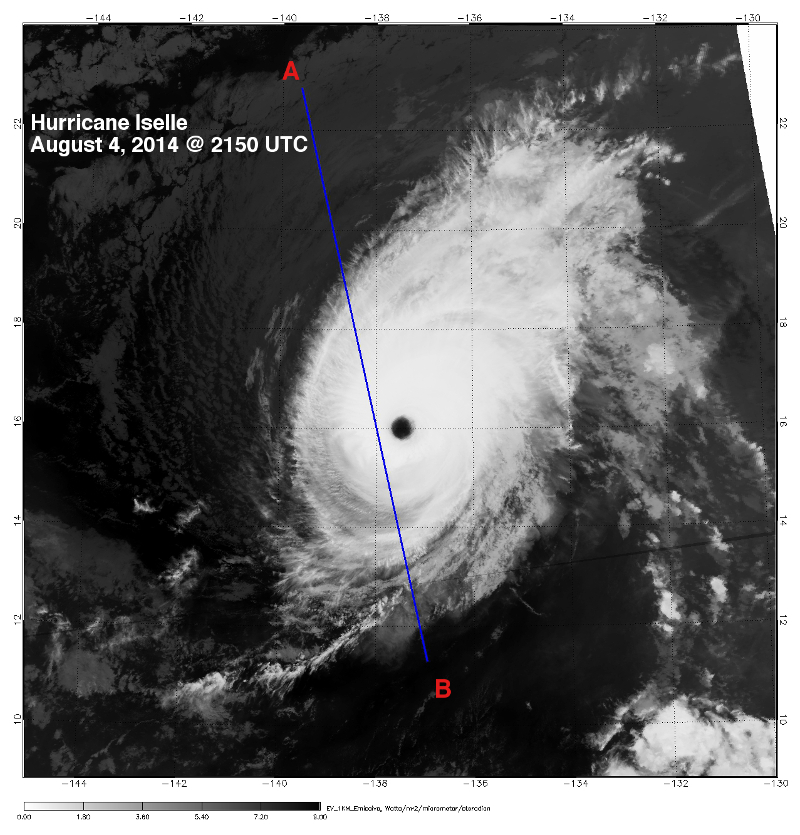
 NASA's twin Van Allen Probes will celebrate on Saturday two years of studying the sun’s influence on our planet and near-Earth space. The probes, shortly after launch in August 2012, discovered a third radiation belt around Earth when only two had previously been detected.

The radiation belts are layers of energetic charged particles held in place by the magnetic field surrounding our planet. The new third belt occurred only occasionally but persisted for as long as a month. This revealed to scientists the dynamic and variable nature of the radiation belts and provided new insight into how they respond to solar activity.

"The primary science objective of the Van Allen Probes is to provide understanding of how particles in the radiation belts form and change in response to energy input from the sun," said Mona Kessel, the mission’s program scientist at NASA Headquarters in Washington.  "The discoveries and understanding gained have far exceeded expectations."

The probes, each weighing just less than 1,500 pounds, were specifically designed to withstand and study the harsh radiation belt region around Earth. The belts are critical regions that have a connection to Earth’s atmosphere and space-based technologies. The belts are affected by solar storms and space weather events and as a result, can swell dramatically. When this occurs, they can pose dangers to communications and GPS satellites, as well as humans in low-Earth orbit.

Formerly known as the Radiation Belt Storm Probes, the mission was renamed Van Allen Probes in November 2012 in honor of Dr. James Van Allen, who discovered the two radiation belts in 1958.

The twin spacecraft have also revealed how particles in the heart of the belts can be accelerated to nearly the speed of light; proven that electrons in the belts are undergoing acceleration from very low frequency plasma waves; and shown persistent stripe-like structures are a common feature of the inner belt, and are caused by Earth’s rotation, a mechanism previously thought to be incapable of such an effect.

“The Van Allen Probes mission has given us the means to validate theories about plasma physics and the acceleration processes going on inside the belts,” said Barry Mauk, Van Allen Probes project scientist at the Johns Hopkins University Applied Physics Laboratory (APL) in Laurel, Maryland. “They also have shown us new structures and features in this region of space, the existence of which we had never suspected. It has been a very illuminating two years, and we look forward to many more with these remarkable spacecraft.”

The Van Allen Probes are the second mission in NASA's Living With a Star (LWS) Program to explore aspects of the connected sun-Earth system that directly affect life and society. LWS is managed by the agency's Goddard Space Flight Center in Greenbelt, Maryland. APL built the spacecraft and manages the mission for the agency’s Science Mission Directorate in Washin


Foto: The twin Van Allen Probes have orbited Earth for 2 years studying the radiation belts around us. Learn more: 1.usa.gov/1nKdx8g

ATLANTIC- Watching 2 tropical low pressure areas in addition to post-tropical cyclone

ATLANTIC- Watching 2 tropical low pressure areas in addition to post-tropical cyclone Cristobal (now 325 miles south-southeast of Cape Race, Newfoundland). This image from 7:45 a.m. EDT was taken from NOAA's GOES-East satellite.
**Low #1. Disorganized cloudiness and thunderstorms over the central Caribbean Sea are associated with a tropical wave. Upper-level winds are expected to remain unfavorable for development during the next day or so. However, environmental conditions could become more conducive for some development when the system moves over the northwestern Caribbean Sea Saturday night or Sunday, and into the southwestern Gulf of Mexico Sunday night or Monday. It has a near zero chance of development over the next 2 days.
**Low #2. A tropical wave near the west coast of Africa is producing minimal shower activity. Environmental conditions are expected to remain unfavorable for development of this system during the next several days while it moves westward near 15 mph across the eastern and central tropical Atlantic. This also has a near zero chance of development.
 
 ATLÁNTICO-Watching 2 zonas de baja presión tropical, además de ciclón post-tropical Cristobal (ahora 325 millas al sur-sureste de Cape Race, Terranova). Esta imagen de 7:45 am EDT fue tomado de la NOAA satélite GOES-Este.
** Low # 1. Nubosidad y tormentas eléctricas sobre el Mar Caribe central desorganizado están asociados a una onda tropical. Se espera que los vientos en los niveles altos de permanecer desfavorable para el desarrollo durante el día siguiente más o menos. Sin embargo, las condiciones ambientales podrían ser más propicio para algún desarrollo cuando el sistema se mueve sobre el noroeste del Mar Caribe la noche el sábado o el domingo, y en el Golfo de México la noche del domingo el suroeste o el lunes. Tiene la posibilidad casi nula de desarrollo en los próximos 2 días.
** Baja # 2. Una onda tropical cerca de la costa occidental de África está produciendo actividad mínima ducha. Se espera que las condiciones ambientales de permanecer desfavorable para el desarrollo de este sistema durante los próximos días mientras se mueve hacia el oeste a cerca de 15 mph a través del Atlántico tropical oriental y central. Esto también tiene una oportunidad de desarrollo cerca de cero.
Foto: Atlántico- Watching 2 zonas de baja presión tropical, además de ciclón post-tropical Cristobal (ahora 325 millas al sur-sureste de Cape Race, Terranova). Esta imagen de 7:45 am EDT fue tomado de la NOAA satélite GOES-Este. ** Low # 1. Nubosidad y tormentas eléctricas sobre el Mar Caribe central desorganizado están asociados a una onda tropical. Se espera que los vientos en los niveles altos de permanecer desfavorable para el desarrollo durante el día siguiente más o menos. Sin embargo, las condiciones ambientales podrían ser más propicio para algún desarrollo cuando el sistema se mueve sobre el noroeste del Mar Caribe la noche el sábado o el domingo, y en el Golfo de México la noche del domingo el suroeste o el lunes. Tiene la posibilidad casi nula de desarrollo en los próximos 2 días. ** Baja # 2. Una onda tropical cerca de la costa occidental de África está produciendo actividad mínima ducha. Se espera que las condiciones ambientales de permanecer desfavorable para el desarrollo de este sistema durante los próximos días mientras se mueve hacia el oeste a cerca de 15 mph a través del Atlántico tropical oriental y central. Esto también tiene una probabilidad casi cero del desarrollo ...
 
Foto: ATLANTIC- Watching 2 tropical low pressure areas in addition to post-tropical cyclone Cristobal (now 325 miles south-southeast of Cape Race, Newfoundland). This image from 7:45 a.m. EDT was taken from NOAA's GOES-East satellite.  
**Low #1. Disorganized cloudiness and thunderstorms over the central Caribbean Sea are associated with a tropical wave.  Upper-level winds are expected to remain unfavorable for development during the next day or so. However, environmental conditions could become more conducive for some development when the system moves over the northwestern Caribbean Sea Saturday night or Sunday, and into the southwestern Gulf of Mexico Sunday night or Monday. It has a near zero chance of development over the next 2 days.  
**Low #2. A tropical wave near the west coast of Africa is producing minimal shower activity.  Environmental conditions are expected to remain unfavorable for development of this system during the next several days while it moves westward near 15 mph across the eastern and central tropical Atlantic. This also has a near zero chance of development.

EASTERN PACIFIC - Hurricane Marie No More!

EASTERN PACIFIC - Hurricane Marie No More!
This infrared image from the AIRS instrument aboard NASA's Aqua satellite shows that the punch has come out of what was once Hurricane Marie- There are no high, cold thunderstorm cloud tops in this infrared image, since Marie moved over cool waters. Full update coming shortly...
 
 PACÍFICO ORIENTAL - Huracán Marie no más!
Esta imagen infrarroja del instrumento AIRS a bordo del satélite Aqua de la NASA muestra que el golpe ha salido de lo que fue el huracán Marie-No hay, frías cimas altas tormenta de nubes en esta imagen infrarroja, ya que Marie se movía sobre las aguas frías. Actualización completa próximamente ...
Foto: EASTERN PACIFIC - Hurricane Marie No More! 
This infrared image from the AIRS instrument aboard NASA's Aqua satellite shows that the punch has come out of what was once Hurricane Marie- There are no high, cold thunderstorm cloud tops in this infrared image, since Marie moved over cool waters.  Full update coming shortly...

video

Video: Satellite Movie Shows Hurricane Cristobal Speeding Through North Atlantic
This animation of NOAA's GOES-East satellite imagery from August 26 through 29 shows Hurricane Cristobal changing into a post-tropical storm in the North Atlantic Ocean.
http://youtu.be/0FQ-6voPtPs

Asteroid Redirect Mission: Identify, Redirect, Explore

Future of Human Space Exploration

Happy Birthday, John Glenn, From the International Space Station

Satellite Movie Shows Hurricane Cristobal Speeding Through North Atlantic

ATLANTIC *Full Update* NASA Sees Hurricane Cristobal Racing Through North Atlantic

ATLANTIC *Full Update* NASA Sees Hurricane Cristobal Racing Through North Atlantic
Satellite imagery shows Hurricane Cristobal racing through the North Atlantic on Friday, August 29 while losing its tropical characteristics
 
 ATLÁNTICO * actualización completa * NASA ve el huracán Cristóbal Racing A través del Atlántico Norte
Las imágenes de satélite muestran que compite huracán Cristóbal a través del Atlántico Norte el viernes 29 de agosto, mientras que perder sus características tropicales.
 
  Satellite imagery shows Hurricane Cristobal racing through the North Atlantic on Friday, August 29 while losing its tropical characteristics. An image from NOAA's GOES-East satellite showed Cristobal headed south of Greenland. The previous day, NASA's TRMM satellite saw heavy rainfall occurring in the hurricane.
In a visible image from NOAA's GOES-East satellite on August 29 at 7:45 a.m. EDT, Hurricane Cristobal was moving through the North Atlantic about 500 miles southwest of Greenland. The image was created by the NASA/NOAA GOES Project at NASA's Goddard Space Flight Center in Greenbelt, Maryland.
At 5 a.m. EDT (0900 UTC) on August 29, Cristobal's maximum sustained winds were near 80 mph (130 kph). The National Hurricane Center forecast noted that Cristobal is forecast to lose its tropical characteristics later today, but it should remain a powerful extra0tropical cyclone over the North Atlantic through Sunday, August 31.


The center of Hurricane Cristobal was located near latitude 42.1 north and longitude 51.7 west. Cristobal was moving toward the northeast near 49 mph (80 kph) and is expected to continue in that direction while slowing down. The estimated minimum central pressure is 973 millibars.
The TRMM Satellite Sees Heavy Rainfall in Cristobal
On the previous day, NASA and the Japan Aerospace Exploration Agency's Tropical Rainfall Measuring Mission (TRMM) satellite had a very good view of Cristobal on August 28 at 12:58 UTC (8:58 a.m. EDT) as the hurricane passed well to the northwest of Bermuda.
At NASA Goddard, rainfall data derived from TRMM's Microwave Imager (TMI) and Precipitation Radar (PR) data was overlaid on a visible/infrared image from NOAA's GOES-East satellite taken August 28 at 1300 UTC (9 a.m. EDT). TRMM PR found some intense thunderstorms producing rain at a rate of almost 78 mm (about 3.1 inches) per hour in a band of precipitation feeding into Cristobal's southeastern side.
The TRMM satellite was close to reaching its northern most coverage when the satellite flew over on August 28, 2014. TRMM covers the tropics, and Cristobal was moving out of range when TRMM captured data on it. The GPM satellite launched by NASA and JAXA on Feb. 27, 2014 will continue viewing hurricane Cristobal as the tropical cyclone moves farther north over the open waters of Atlantic Ocean.


Headed to the United Kingdom
The U.K. Meteorological Service (UKMS) forecast for Cristobal calls for the storm to move northeast across the Atlantic toward Iceland, staying well away from the U.K. The UKMS noted that Cristobal could bring stronger winds across northwestern parts of Scotland and rain across the United Kingdom on Sunday, August 31 and Monday, September 1.


 Las imágenes de satélite muestran que compite huracán Cristóbal a través del Atlántico Norte el viernes 29 de agosto, mientras que perder sus características tropicales. Una imagen de la NOAA GOES-Este satélite mostró Cristóbal dirigió al sur de Groenlandia. El día anterior, el satélite TRMM de la NASA vio fuertes lluvias que ocurren en el huracán.

En una imagen visible a partir de la NOAA satélite GOES-Oriente el 29 de agosto a las 7:45 am EDT, el huracán Cristóbal se movía a través del Atlántico Norte a unos 500 km al suroeste de Groenlandia. La imagen fue creada por la NASA / NOAA del GOES Proyecto del Centro de Vuelo Espacial Goddard de la NASA en Greenbelt, Maryland.

A las 5 am EDT (0900 GMT) el 29 de agosto, los vientos máximos sostenidos de Cristóbal eran cerca de 80 mph (130 kph). El pronóstico del Centro Nacional de Huracanes señaló que Cristóbal se prevé perder sus características tropicales más tarde hoy, pero debe seguir siendo un poderoso ciclón extra0tropical sobre el Atlántico Norte hasta el domingo 31 de agosto.

El centro del huracán Cristóbal estaba ubicado cerca de la latitud 42,1 norte y longitud 51.7 oeste. Cristóbal se movía hacia el noreste, cerca de 49 mph (80 kph) y se espera que continúe en esa dirección, mientras que disminuir la velocidad. La presión central mínima estimada es de 973 milibares.

El satélite TRMM ve fuertes lluvias en Cristóbal

El día anterior, la NASA y las lluvias tropicales de la Agencia de Exploración Aeroespacial de Japón Misión de Medición (TRMM) tuvieron una muy buena vista de Cristóbal el 28 de agosto a las 12:58 UTC (8:58 am EDT) como el huracán pasó bien en el noroeste de las Bermudas.

En la NASA Goddard, datos de precipitación derivan de microondas Imager del TRMM (TMI) y radar de precipitación de datos (PR) se sobrepuso en una imagen visible / infrarrojo de NOAA GOES-Este satélite tomada el 28 de agosto a las 1300 UTC (9 am EDT). TRMM PR encontró algunas tormentas intensas que producen la lluvia a una velocidad de casi 78 mm (aproximadamente 3,1 pulgadas) por hora en una banda de alimentación de la precipitación en el lado sureste de Cristóbal.

El satélite TRMM fue cerca de alcanzar su cobertura más al norte cuando el satélite sobrevoló el 28 de agosto de 2014. TRMM cubre los trópicos, y Cristóbal se movía fuera de rango cuando TRMM capturado los datos en él. El satélite GPM lanzado por la NASA y JAXA en febrero 27, 2014 seguirán viendo huracán Cristóbal como el ciclón tropical se mueve hacia el norte sobre las aguas abiertas del Océano Atlántico.

Dirigido al Reino Unido

El U.K. Servicio Meteorológico (UKMS) pronóstico para Cristóbal pide la tormenta para mover al noreste a través del Atlántico hacia Islandia, mantenerse bien lejos del Reino Unido El UKMS señaló que Cristóbal podría traer vientos fuertes en toda partes del noroeste de Escocia y la lluvia en todo el Reino Unido el Domingo, 31 de agosto y el lunes, 1 de septiembre.
 

jueves, 7 de agosto de 2014

NW PACIFIC - Genevieve Becomes A Super-typhoon

NW PACIFIC - Genevieve Becomes A Super-typhoon
(details to follow) - but here's a snapshot of the storm from the MODIS instrument aboard NASA's Terra satellite. This was taken August 6 at 22:45 UTC (6:45 p.m. EDT). NASA-NOAA's Suomi NPP satellite captured another image (coming in the next update)
 
 NW PACÍFICO - Genevieve se convierte en un super-tifón
(detalles a seguir) - pero aquí es una instantánea de la tormenta del instrumento MODIS a bordo del satélite Terra de la NASA. Esta fue tomada 06 de agosto a las 22:45 UTC (18:45 EDT). Satélite Suomi NPP de la NASA-NOAA capturó otra imagen (que viene en la próxima actualización)
Foto: NW PACIFIC - Genevieve Becomes A Super-typhoon  
(details to follow) - but here's a snapshot of the storm from the MODIS instrument aboard NASA's Terra satellite. This was taken August 6 at 22:45 UTC (6:45 p.m. EDT). NASA-NOAA's Suomi NPP satellite captured another image (coming in the next update)

CENTRAL PACIFIC

CENTRAL PACIFIC * Full update/Warnings*
NASA Sees Heavy Rainfall in Iselle as the Hurricane Nears Hawaii
A NASA satellite has observed heavy rainfall in Hurricane Iselle on its approach to Hawaii. (In this image, Iselle is to the left, and Julio is to the right)
STORY/IMAGES: http://www.nasa.gov/content/goddard/iselle-eastern-pacific-ocean


 CENTRAL PACIFIC * full de actualización / Advertencias *
NASA ve fuertes lluvias en Iselle como el huracán se acerca a Hawaii
Un satélite de la NASA ha observado fuertes lluvias en el huracán Iselle en su enfoque a Hawai. (En la foto, Iselle está a la izquierda, y Julio está a la derecha)
HISTORIA / IMAGES: http://www.nasa.gov/content/goddard/iselle-oriental y el Pacífico-
océano


Video especial: Película de satélite

Special VIdeo: Satellite Movie Shows Hurricane Iselle and Julio Moving Toward Hawaii
This animation of NOAA's GOES-East satellite imagery from August 2 through 7 shows the movement of Hurricanes Iselle (left) and Julio (right) toward the Hawaiian Islands. Credit: NASA/NOAA GOES Project https://www.youtube.com/watch?v=3cEVueQ45-U


Video especial: Película de satélite muestra el huracán Iselle y Julio Ir hacia Hawaii
Esta animación de NOAA GOES-Este las imágenes de satélite a partir del 2 de agosto al 7 muestra el movimiento de los huracanes Iselle (izquierda) y Julio (derecha) hacia las islas de Hawai. Crédito: NASA / NOAA VA Proyecto https://www.youtube.com/watch?v=3cEVueQ45-U

Hurricane ...Emit a Gamma-Ray Flash

NW PACIFIC *Full Update* NASA Sees Hurricane Julio Organize and Emit a Gamma-Ray Flash
NASA's Fermi and Aqua satellites captured two different views of bursts of strength show by Hurricane Julio as it intensified. NASA's Fermi satellite saw a gamma-ray flash from Julio, while NASA's Aqua satellite saw Julio become more structurally organized as a hurricane. STORY/IMAGES:
http://www.nasa.gov/content/goddard/julio/
 
 
  NW PACÍFICO * actualización completa * NASA ve el huracán Julio Organizar y Emitir una flash Gamma-Ray
Satélites Fermi y Aqua de la NASA capturó a dos puntos de vista diferentes de ráfagas de fuerza mostrado por el huracán Julio, ya que se intensificó. Satélite Fermi de la NASA vio un destello de rayos gamma de Julio, mientras que el satélite Aqua de la NASA vio Julio organizarse más estructuralmente como un huracán. HISTORIA / FOTO:
http://www.nasa.gov/content/goddard/julio/

NW PACIFIC Super-typhoon

NW PACIFIC *Here's the full update on Super-typhoon Genevieve as promised: NASA Sees Genevieve Cross International Date Line as a Super-Typhoon
Tropical Storm Genevieve had ups and downs in the Eastern Pacific and Central Pacific over the last week but once the storm crossed the International Dateline in the Pacific, it rapidly intensified into a Super Typhoon.
http://www.nasa.gov/content/goddard/genevieve-eastern-pacific-ocean/
 
 
 NW PACÍFICO * Aquí está la actualización completa sobre el Super-tifón Genevieve según lo prometido: NASA ve Date Line Genevieve Cross International como un Super-Typhoon
La tormenta tropical Genevieve tuvo altibajos en el Pacífico Oriental y el Pacífico central durante la última semana, pero una vez que la tormenta cruzó la línea de fecha internacional en el Pacífico, se intensificó rápidamente en un súper tifón.
http://www.nasa.gov/content/goddard/genevieve-oriental y el Pacífico-ocean/

Hurricane Iselle

Hurricane Iselle

CloudSat overpassed Hurricane Iselle in the Pacific Ocean on August 4, 2014 at 2150 UTC. Iselle contained maximum sustained winds of 132 mph (115 knots) with a minimum central pressure of 951 mb. CloudSat overpassed just to the west of the center of compact storm intersecting the eyewall.
The Moderate Resolution Imaging Spectroradiometer (MODIS) on NASA's Aqua satellite captured the infrared (IR) (Figure 1) image taken a few minutes before the CloudSat overpass (Figure 2) denoted by the blue line A->B). The 1km Enhanced Infrared (IR) Imagery, Figure 3, also shows the CloudSat track during the same time period. This imagery distinguishes between cold and warm cloud top temperatures using IR imagery (higher cloud tops -> colder temperatures).
Hurricane Iselle was moving slowly westward towards Hawaii during the time of this overpass. The structure of Iselle is the classic annular structure with a well defined eye surrounded by a ring of deep convection. The CloudSat overpass (Figure 2) intersects this section of dense, convective cloud tops with cloud top heights around 15-16 km. The CloudSat cloud profiling signal attenuates in areas of moderate to heavy precipitation, quite evident from the convective cores in the CloudSat overpass. Cirrus cloud tops extend outwards from the storm to the northwest and southeast along the track of the descending CloudSat overpass.
An animation containing GOES satellite imagery with CloudSat imagery overlaid is shown in Figure 4 (courtesy Shigeru Suzuki of JPL).
Figure 1. MODIS IR imagery (courtesy NOAA LAADS Web).
Figure 2. CloudSat overpass track (courtesy CloudSat Data Processing Center).
Figure 3. 1km Remapped Color Enhanced Infrared Imagery (courtesy RAMMB).

Figure 4. Hurricane Iselle Animation - Pacific Ocean, August 4, 2014.

References:
NHC, Hurricane Iselle Advisory Archive, Retrieved August 6, 2014.
MODIS imagery, LAADS Web, Retrieved August 6, 2014.
1km Remapped Color Enhanced Infrared Imagery, Hurricane Iselle, Retrieved August 6, 2014. 


 huracán Iselle

CloudSat sobrepasado huracán Iselle en el Océano Pacífico el 4 de agosto de 2014 a 2150 UTC. Iselle contenía vientos máximos sostenidos de 132 mph (115 nudos) con una presión mínima central de 951 mb. CloudSat sobrepasado justo al oeste del centro de la tormenta compacto que corta la pared del ojo.

La resolución moderada (MODIS) en el satélite Aqua de la NASA capturó los rayos infrarrojos (IR) imagen tomada pocos minutos antes de que el paso elevado CloudSat (Figura 1) (Figura 2) indicada por la línea azul A-> B). El Enhanced Infrared (IR) Imágenes de 1km, Figura 3, muestra también la pista CloudSat durante el mismo período de tiempo. Esta imaginería distingue entre temperaturas superiores nube fría y caliente, utilizando imágenes de IR (mayores cimas de las nubes -> temperaturas más frías).

Huracán Iselle se movía lentamente hacia el oeste hacia Hawai durante el tiempo de este paso elevado. La estructura de Iselle es la estructura anular clásico con un ojo bien definido rodeado por un anillo de convección profunda. El paso elevado CloudSat (Figura 2) se cruza esta sección de, densas nubes convectivas con altos nube alturas alrededor de 15-16 km. La señal de perfiles de nubes CloudSat atenúa en las zonas de moderada a fuertes precipitaciones, bastante evidente a partir de los núcleos convectivos en el paso elevado CloudSat. Cirrus cimas de las nubes se extienden hacia el exterior de la tormenta hacia el noroeste y sureste a lo largo de la pista del paso a desnivel descendente CloudSat.

Una animación que contiene VA imágenes de satélite CloudSat con imágenes superpuestas se muestra en la Figura 4 (cortesía Shigeru Suzuki de JPL).

Figura 1. MODIS IR imágenes (cortesía de NOAA LAADS Web).

Figura 2. CloudSat pista puente (cortesía CloudSat Centro de Procesamiento de Datos).

Figura 3. 1 kilometro Nueva Correspondencia Color realzado imágenes infrarrojas (RAMMB cortesía).


Figura 4. huracán Iselle Animación - Océano Pacífico 4 de agosto de 2014.

Referencias:

NHC, el huracán Archivo Asesor Iselle, Consultado el 06 de agosto 2014.

Imágenes MODIS, LAADS Web, Obtenido 06 de agosto 2014.

1 kilometro Nueva Correspondencia Color realzado infrarrojos Imagery, Iselle huracán, Obtenido 06 de agosto 2014.


The Sun sported a very long filament


The Sun sported a very long filament (over 30 times the size of Earth) that angled diagonally across its surface for over a week (July 31 - Aug. 6, 2014). Filaments are clouds of cooler gas suspended above the Sun's surface by magnetic forces. They are notoriously unstable and often break apart in just hours or days. So far, this one has held together as it rotated along with the Sun for over a week. The images were taken in the 193 Angstrom wavelength of extreme ultraviolet light and were tinted red instead of its usual brown hue


 El sol lucía un filamento muy largo (más de 30 veces el tamaño de la Tierra) que un ángulo diagonal a través de su superficie durante más de una semana (julio 31 a agosto 6, 2014). Los filamentos son nubes de gas más frío suspendidos por encima de la superficie del Sol por fuerzas magnéticas. Ellos son notoriamente inestables y con frecuencia se rompen en sólo unas horas o días. Hasta el momento, ésta se ha mantenido unida ya que gira junto con el Sol durante más de una semana. Las imágenes fueron tomadas en el 193 Angstrom longitud de onda de la luz ultravioleta extrema y se tiñen de color rojo en lugar de su color marrón habitual.


Credit: NASA/Solar Dynamics Observatory
#nasa #sdo #sun #filament #space #solar
Foto: The Sun sported a very long filament (over 30 times the size of Earth) that angled diagonally across its surface for over a week (July 31 - Aug. 6, 2014). Filaments are clouds of cooler gas suspended above the Sun's surface by magnetic forces. They are notoriously unstable and often break apart in just hours or days. So far, this one has held together as it rotated along with the Sun for over a week. The images were taken in the 193 Angstrom wavelength of extreme ultraviolet light and were tinted red instead of its usual brown hue. 

Credit: NASA/Solar Dynamics Observatory
#nasa #sdo #sun #filament #space #solar 


Asteroid Redirect Mission: Identify, Redirect, Explore

Robonaut Upgrades, Spacewalk

Robonaut Upgrades, Spacewalk Preps and Cargo Ops for Station Crew


Spacewalk and visiting vehicle preparations, materials research, telerobotics and upgrades for the International Space Station’s mechanical crew member were the focus of the Expedition 40 crew’s workday Thursday.
Expedition 40 Commander Steve Swanson of NASA and his team of five flight engineers began the day with the usual 2 a.m. EDT reveille, followed by a daily planning conference with the international partners’ flight control centers around the world to discuss the day’s activities.


Flight Engineer Reid Wiseman
 Flight Engineer Reid Wiseman works with the Binary Colloidal Alloy Test-C1 experiment aboard the International Space Station.


 Afterward, Swanson went to work in the U.S. Destiny laboratory to begin two days of mobility upgrades for the station’s robotic crew member, Robonaut 2. Since arriving aboard the station in May 2011, Robonaut has tackled a series of increasingly complex tasks as engineers test the feasibility of a humanoid robot taking over routine and mundane chores to free up the astronauts for more critical work. For the next phase of testing, Robonaut will be outfitted with a pair of climbing legs to enable it to move around the station. These legs, which are equipped with end effectors to allow them to grip handrails and sockets, were delivered to the station during the SpaceX-3 cargo mission in April. Swanson is installing new processors, circuit boards, cables and fans into Robonaut to pave the way for the addition of its legs at a later date.
NASA astronaut Reid Wiseman started the workday mixing some new test samples for the Canadian version of the Binary Colloidal Alloy Test, or BCAT-C1. Results from this investigation of colloids – mixtures of small particles distributed throughout a liquid – will help materials scientists to develop new consumer products with unique properties and longer shelf lives.
Wiseman later helped out European Space Agency (ESA) astronaut Alexander Gerst with the stowage of trash and unneeded items inside Orbital Sciences’ Cygnus cargo vehicle berthed at the Earth-facing port of the Harmony node. Cygnus, which arrived on July 16 with nearly 3,300 pounds of science and supplies, will be detached from Harmony by the station’s Canadarm2 robotic arm on Aug. 15 and released by the crew for a destructive re-entry over the Pacific Ocean.
Wiseman then rounded up the tools and equipment that will be used next week to remove and replace a fan pump separator in one of the U.S. spacesuits.
On the Russian side of the complex, cosmonauts Alexander Skvortsov and Oleg Artemyev gathered spacewalking tools and hardware that they will need during their spacewalk slated for Aug. 18 and then reviewed the planned tasks during a conference with the team at the Russian Mission Control Center outside Moscow.
During the spacewalk, Skvortsov and Artemyev will exit through a hatch in the Pirs docking compartment to deploy a nanosatellite, install two experiment packages and retrieve two others. NASA Television will provide live coverage of the spacewalk beginning at 10 a.m.
Cosmonaut and future station Commander Max Suraev began the day reinstalling some communication system amplifiers in the Zvezda service module before assisting Skvortsov and Artemyev with hand ergometry assessments.
After a break for lunch, Skvortsov and Gerst teamed up for more simulator training as they prepare to watch over the automated rendezvous and docking of the ESA’s fifth and final Automated Transfer Vehicle (ATV-5). Nicknamed the “Georges Lemaitre” in honor of the Belgian physicist and astronomer who first proposed the Big Bang theory, ATV-5 will deliver more than seven tons of scientific experiments, food and other supplies when it docks to the aft end of Zvezda on Tuesday at 9:30 a.m. NASA Television coverage will begin at 8 a.m.
The “Georges Lemaitre” is scheduled to fly directly under the station Friday at a distance of a little less than four miles to test sensors and radar systems designed to provide data for European engineers’ design of future spacecraft. After the ”fly under” of the station, the ATV-5 will move in front of the station and transition above and then behind the station for the final four days of its two-week rendezvous. ATV-5 launched atop an Ariane 5 rocket from Kourou, French Guiana, on July 29.


 Taking a brief break from his work, Gerst talked with ABC News’ Gina Sunseri and Bill Harwood of CBS News during an in-flight event in the Columbus laboratory. The German astronaut discussed his work aboard the station as well as the status of ESA’s Rosetta spacecraft now in orbit around comet 67P/Churyumov-Gerasimenko.
Afterward, Gerst remotely commanded the car-sized Eurobot rover located at the European Space Research and Technology Centre (ESTEC) in the Netherlands as part of a technology demonstration known as the Multi-End-To-End Robotic Operations Network, or METERON. This investigation serves as a precursor and proof of concept for future human exploration scenarios including immersive remote control of a robot by an astronaut in orbit around a distant target such as the moon or Mars.
With the day’s Robonaut upgrades completed, Swanson wrapped up his day with more Ocular Health exams as flight surgeons keep close track on any changes in the crew’s eyesight. NASA recently identified that some astronauts experience changes in their vision, which might be related to effects of microgravity on the cardiovascular system as the body’s fluids tend to move toward the upper body and head and cause the pressure in the skull to rise. With assistance from the Ocular Health team on the ground, Wiseman examined the commander’s eyes using optical coherence tomography equipment and a fundoscope.
Suraev performed another session of the Calcium experiment, which examines the causes of the loss of bone density that occurs in a weightless environment. For this study, Russian researchers are looking at the solubility of calcium phosphates and human bone samples in water in space.
Next, Suraev tested the secondary power supply for the Napor-mini RSA experiment, which utilizes an optical telescope and a small radar system for monitoring Earth’s environment. He rounded out his workday performing routine maintenance on the SOZh life-support system in Zvezda.
Gerst and Skvortsov had time for a conference call with the ground teams to discuss the day’s ATV training before the entire crew gathered for the evening’s daily planning conference to wrap up the workday aboard the station.


Flight Engineer Alexander Gerst


 Flight Engineer Alexander Gerst talks with reporters from ABC News and CBS News during an in-flight event in the International Space Station's Columbus laboratory.

........................................................................................................................................................
 Robonaut Actualizaciones, Paseo espacial Preps y de Carga Ops para Estaciones Crew

 Paseo espacial y preparaciones de vehículos que visitan, la investigación de materiales, telerobótica y mejoras para tripulante mecánica de la Estación Espacial Internacional fueron el foco de la jornada laboral de la Expedición 40 de la tripulación Jueves.

Expedición 40 Comandante Steve Swanson, de la NASA y su equipo de cinco ingenieros de vuelo comenzaron el día con el habitual 02 a.m. EDT toque de diana, seguido de una conferencia de planificación diaria con los centros de control de vuelo de los socios internacionales de todo el mundo para discutir las actividades del día.


 Ingeniero de vuelo Reid Wise
Flight Engineer Reid Wiseman
man trabaja con el experimento binario coloidal aleación Test-C1 a bordo de la Estación Espacial Internacional.

 Después, Swanson se puso a trabajar en el laboratorio Destiny de Estados Unidos para comenzar dos días de actualizaciones de movilidad para el miembro de la tripulación robótico de la estación, Robonaut 2 Desde su llegada a bordo de la estación, en mayo de 2011, Robonaut ha abordado una serie de tareas cada vez más complejas como ingenieros prueban la viabilidad de una toma de robot humanoide más de las tareas rutinarias y mundanas para liberar a los astronautas para el trabajo más crítico. Para la siguiente fase de pruebas, Robonaut será equipado con un par de subir las piernas para permitir que se mueva alrededor de la estación. Estas piernas, que están equipadas con efectores terminales para que puedan pasamanos de agarre y enchufes, fueron entregados a la estación durante la misión de SpaceX-3 de carga en abril. Swanson es la instalación de los nuevos procesadores, tarjetas de circuitos, cables y ventiladores en Robonaut para allanar el camino para la incorporación de sus piernas en una fecha posterior.

Astronauta de la NASA Reid Wiseman comenzó la jornada de trabajo mezclando algunas nuevas muestras de prueba para la versión canadiense de la prueba de la aleación binaria coloidal, o BCAT-C1. Los resultados de esta investigación de coloides - mezclas de partículas pequeñas distribuidas a lo largo de un líquido - ayudarán a los científicos de materiales para desarrollar nuevos productos de consumo con propiedades únicas y vida más prolongada.

Wiseman más tarde ayudó a salir de la Agencia Espacial Europea (ESA) el astronauta Alexander Gerst con la estiba de basura y artículos innecesarios dentro Cygnus vehículo de carga Orbital Sciences 'atracado en el puerto de la Tierra frente del nodo Harmony. Cygnus, que llegó el 16 de julio con casi 3,300 libras de ciencia y suministros, será separado de la armonía por Canadarm2 brazo robótico de la estación el 15 de agosto y puesto en libertad por la tripulación para una reentrada destructiva sobre el Océano Pacífico.

Wiseman entonces redondea las herramientas y equipos que se utilizarán la próxima semana para retirar y reemplazar un separador de la bomba del ventilador en uno de los trajes espaciales estadounidenses.

En el lado ruso del complejo, los cosmonautas Alexander Skvortsov y Oleg Artemyev reunieron herramientas y hardware que necesitarán durante su caminata espacial programada para el 18 de agosto caminatas espaciales y luego revisaron las tareas previstas durante una reunión con el equipo del Centro de Control de Misión ruso fuera Moscú.

Durante la caminata espacial, Skvortsov y Artemyev saldrán a través de una escotilla en el compartimiento de acoplamiento Pirs para desplegar una nanosatélites, instalar dos paquetes de experimentos y recuperar a otros dos. NASA Television ofrecerá cobertura en vivo de la caminata espacial que comienza a las 10 am

Cosmonauta y futura estación Comandante Max Suraev comenzaron el día de volver a instalar algunos amplificadores de sistemas de comunicación en el módulo de servicio Zvezda antes de ayudar Skvortsov y Artemyev con evaluaciones ergometría mano.

Después de una pausa para el almuerzo, Skvortsov y Gerst unieron para más entrenamiento en simulador, mientras se preparan para vigilar la cita automatizada y acoplamiento de la quinta y última Vehículo Automatizado de Transferencia de la ESA (ATV-5). Apodado el "Georges Lemaitre" en honor del físico y astrónomo belga que propuso por primera vez la teoría del Big Bang, el ATV-5 entregará más de siete toneladas de experimentos científicos, alimentos y otros suministros cuando se acopla al extremo de popa del Zvezda el martes a las 9:30 am cobertura de televisión de la NASA comenzará a las 8 am

El "Georges Lemaitre" está programado para volar directamente bajo la estación de viernes a una distancia de un poco menos de cuatro kilómetros para probar los sensores y los sistemas de radar diseñados para proporcionar datos para el diseño de los ingenieros europeos de las futuras naves espaciales. Después de la "volar bajo" de la estación, el ATV-5 se moverá delante de la estación y de transición por encima y luego detrás de la estación de los últimos cuatro días de su encuentro de dos semanas. ATV-5 lanzado encima de un cohete Ariane 5 desde Kourou, en la Guayana Francesa, el 29 de julio.


Robonaut with legs
Robonaut 2 de la NASA se muestra con sus piernas que suben durante las pruebas en tierra.


omando un breve descanso de su trabajo, Gerst habló con ABC News 'Gina Sunseri y Bill Harwood de CBS News durante un evento en vuelo en el laboratorio Columbus. El astronauta alemán habló de su trabajo a bordo de la estación, así como el estado de la nave espacial Rosetta de la ESA en órbita alrededor del cometa 67P / Churyumov-Gerasimenko.

Después, Gerst ordenó remotamente el Eurobot rover-coche de tamaño situado en el Centro de Investigación y Tecnología Espacial Europea (ESTEC) en los Países Bajos como parte de una demostración de la tecnología conocida como la robótica de Operaciones de Red Multi-End-To-End, o METERON. Esta investigación sirve como un precursor y una prueba de concepto para futuros escenarios de exploración humanos, incluyendo el control remoto de inmersión de un robot por un astronauta en órbita alrededor de un objetivo distante, como la Luna o Marte.

Con las actualizaciones Robonaut del día terminaron, Swanson concluyó su día con más exámenes Ocular Salud como cirujanos de vuelo mantienen un estrecho seguimiento de cualquier cambio en la visión de la tripulación. NASA identificó recientemente que algunos astronautas experimentan cambios en su visión, lo que podría estar relacionado con los efectos de la microgravedad sobre el sistema cardiovascular que los fluidos del cuerpo tienden a moverse hacia la parte superior del cuerpo y la cabeza y hacer que la presión en el cráneo se eleve. Con la ayuda del equipo de Salud Ocular en el suelo, Wiseman examinó los ojos del comandante utilizando equipos de tomografía de coherencia óptica y un fundoscope.

Suraev realizó otra sesión del experimento de calcio, que examina la

s causas de la pérdida de densidad ósea que se produce en un ambiente sin gravedad. Para este estudio, los investigadores rusos están buscando en la solubilidad de los fosfatos de calcio y muestras de huesos humanos en el agua en el espacio.

A continuación, Suraev probó la fuente de alimentación secundaria para el Napor mini-experimento RSA, que utiliza un telescopio óptico y un sistema de radar pequeño para vigilar el medio ambiente de la Tierra. Él completó su jornada de trabajo de realizar el mantenimiento de rutina en el sistema de soporte vital Sozh en Zvezda.

Gerst y Skvortsov tuvieron tiempo para una llamada de conferencia con los equipos de tierra para discutir la formación de ATV del día antes de que toda la tripulación se reunieron para la conferencia de planificación diaria de la tarde para terminar la jornada de trabajo a bordo de la estación.


Flight Engineer Alexander Gerst


Ingeniero de Vuelo Alexander Gerst habla con reporteros de ABC News y CBS News durante un evento en vuelo en el laboratorio Columbus de la Estación Espacial Internacional.